Fundamentals of QGIS Course Wales

Price £195 (no VAT) Time 9:00am-2:00pm Venue Llynfi Enterprise Centre, Bridgend County, CF34 0BQ
Course Overview - Fundamentals of QGIS
Welcome to our Fundamentals of QGIS one-day course, your gateway to mastering the basics of Geographic Information System (GIS) with the power of QGIS. Designed to provide a compact yet comprehensive learning experience, this course is your stepping stone into the world of spatial data analysis and visualisation. In just one day, you will embark on a journey through the key components of QGIS, from understanding its user-friendly interface to acquiring essential skills in data management, map creation, and spatial analysis. Discover how to import various data formats, create eye-catching maps, and perform fundamental spatial operations that unearth valuable insights.
Through hands-on exercises and practical examples, you will gain confidence in navigating QGIS, editing geospatial data, and utilising its diverse set of tools. By the end of the day, you will be equipped to harness the potential of QGIS for your projects, whether you're a beginner seeking to enter the world of GIS or a professional expanding your skill set. Join us for this intensive and enlightening one-day journey into the Fundamentals of QGIS, and unlock the power to transform spatial data into informed decisions and captivating visualisations.
Course Content - Fundamentals of QGIS
- Introduction to QGIS and its Role in GIS
- QGIS Interface and Navigation
- Importing Different Data Formats into QGIS
- Data Visualisation and Symbology
- Basic Spatial Analysis in QGIS
- Creating and Editing Spatial Data
- Geoprocessing and Spatial Queries
- Working with Attribute Data and Tables
- Creating Print Layouts and Maps
- Introduction to Plugins and Extensions
- Georeferencing and Coordinate Systems in QGIS
- Project Management and Best Practices in QGIS
Who is this course for?
Ideal for both beginners and intermediate GIS users, this course introduces the fundamentals of working with QGIS, a robust open-source GIS software. If you're an aspiring GIS analyst, geospatial technician, planner, or researcher, this course is your gateway to understanding QGIS's interface, managing geospatial data, performing basic analyses, and creating compelling maps. Gain confidence in using QGIS to handle spatial data effectively, irrespective of your prior GIS experience.
GIS Data Formats, Design & Quality
Price £195 (no VAT) Time 9:00am-2:00pm Venue Llynfi Enterprise Centre, Bridgend County, CF34 0BQ
Course Overview - GIS Data Formats, Design & Quality
Welcome to our GIS Data Formats, Design & Quality one-day course. In today's fast-paced world, Geographic Information Systems (GIS) have become integral tools for understanding spatial relationships, making informed decisions, and solving real-world problems. This course is designed to equip you with essential knowledge and practical skills to effectively manage, analyse, and present geospatial data. Throughout the day, you will delve into the intricate realm of GIS data formats, exploring the diverse ways in which geographic information is structured and stored. From industry-standard shapefiles to cutting-edge geodatabases and web-based formats like GeoJSON, you will gain hands-on experience in handling various data formats, ensuring compatibility, and mitigating potential data loss or corruption.
Understanding the principles of data design is crucial for creating meaningful and visually compelling maps. This course will guide you through the art of cartographic representation, teaching you how to choose appropriate symbology, colour schemes, and labeling techniques to effectively communicate spatial information to your target audience. However, the true value of geospatial data lies not only in its visual appeal but also in its quality and accuracy. In this course, you will learn strategies to assess data quality, address common errors, and enhance the reliability of your GIS projects. By mastering techniques to validate, clean, and refine data, you will contribute to the production of reliable analyses and informed decision-making processes.
Course Content - GIS Data Formats, Design & Quality
- Introduction to GIS Data Formats and Importance
- Common GIS Data Formats (Shapefiles, Geodatabases, etc.)
- Web-based Geospatial Data Formats (GeoJSON, KML, etc.)
- Understanding Data Design Principles in GIS
- Symbology and Cartographic Representation
- Effective Labeling Techniques
- Colour Theory for Map Design
- Data Quality Assessment and Assurance
- Error Detection and Correction Methods
- Georeferencing and Coordinate Systems
- Data Conversion and Transformation
- Best Practices for GIS Data Management and Design
Who is this course for?
Geared towards GIS practitioners, data managers, cartographers, and anyone working with geospatial data, this course offers a deep dive into the intricate realm of GIS data formats, design, and quality control. If you're committed to enhancing the accuracy, reliability, and visual appeal of your geospatial projects, this course provides the knowledge and techniques needed to navigate diverse data formats, design captivating maps, and ensure data integrity through effective quality control measures.
Geospatial & Environmental Analysis Course Wales
Price £195 (no VAT) Time 9:00am-2:00pm Venue Llynfi Enterprise Centre, Bridgend County, CF34 0BQ
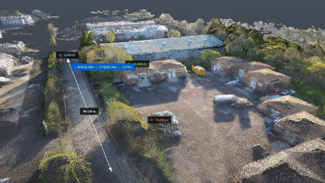
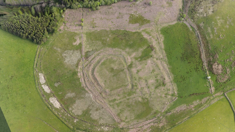
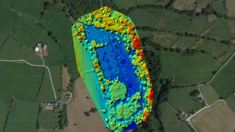
Course Overview - Geospatial & Environmental Analysis
Welcome to our dynamic world of geospatial and environmental analysis. In this one-day course, we invite you to explore the critical intersection of geography and environmental science, where data-driven insights shape our understanding of the natural world. Geospatial analysis has become an indispensable tool for unraveling complex environmental challenges. Over the course of the day, you will embark on a captivating journey that introduces you to the core principles and techniques of harnessing geospatial data for environmental analysis.
From mapping land cover changes to modelling wildlife habitats and assessing urban heat islands, you will gain hands-on experience in applying geospatial tools to solve real-world environmental problems. You will learn to navigate Geographic Information Systems (GIS) software, interpret spatial patterns, and execute advanced analyses that drive informed decision-making. Through engaging discussions and practical exercises, you will discover how to integrate diverse data sources, perform spatial modelling, and communicate your findings effectively through visualisations. By the end of the course, you will be equipped with the knowledge and skills to tackle environmental challenges with confidence, fostering a deeper connection between science, technology, and the natural world.
Course Content - Geospatial & Environmental Analysis
- Introduction to Geospatial Analysis in Environmental Science
- Key Concepts in Environmental Analysis
- Geospatial Data Acquisition and Sources
- Data Cleaning and Preprocessing
- Introduction to Geographic Information Systems (GIS)
- Geospatial Visualisation for Environmental Data
- Spatial Analysis Techniques for Environmental Studies
- Mapping Land Use and Land Cover Changes
- Modelling Habitats and Ecological Niches
- Assessing Environmental Impacts and Risks
- Urban Heat Island Analysis
- Communication of Geospatial Environmental Findings
Who is this course for?
This course is tailored for environmental enthusiasts, researchers, professionals, and students eager to explore the synergy between geospatial technology and environmental science. Whether you're an environmental consultant, ecologist, urban planner, or simply passionate about understanding the Earth's ecosystems, this course equips you with the skills to analyse spatial data, model environmental phenomena, and contribute to informed environmental decision-making.
Geospatial Analysis Project Course Wales
Price £195 (no VAT) Time 9:00am-2:00pm Venue Llynfi Enterprise Centre, Bridgend County, CF34 0BQ
Course Overview - Geospatial Analysis Project
Welcome to our Geospatial Analysis Project one-day course, where theory meets practical application in a dynamic learning experience. In this intensive course, you will immerse yourself in the world of geospatial analysis by undertaking a hands-on project that mirrors real-world challenges. In just one day, you will go beyond theory and dive straight into crafting a geospatial analysis project from start to finish. Guided by seasoned experts, you will learn how to define a problem, gather and prepare relevant data, conduct spatial analyses, and derive meaningful insights.
Throughout the course, you will leverage cutting-edge Geographic Information Systems (GIS) tools, enhancing your proficiency in manipulating spatial data and performing geoprocessing tasks. Whether you're a GIS novice or seeking to refine your skills, this course empowers you to navigate spatial datasets, interpret patterns, and make informed decisions. By the end of the day, you will have completed a comprehensive geospatial analysis project, showcasing your ability to transform raw data into actionable knowledge. Join us for this transformative journey, where you will gain practical expertise and a deep understanding of how geospatial analysis drives impactful solutions across various industries.
Course Content - Geospatial Analysis Project
- Introduction to Geospatial Analysis
- Defining the Project Scope and Objectives
- Data Acquisition and Selection
- Data Preparation and Cleaning
- Introduction to Geographic Information Systems (GIS)
- Navigating GIS Software Interface
- Basic Spatial Queries and Selections
- Data Visualisation Techniques
- Spatial Analysis Methods
- Geoprocessing and Data Transformation
- Creating Spatial Models
- Spatial Interpolation Techniques
Who is this course for?
The Geospatial Analysis Project course caters to individuals eager to put theory into practice by undertaking comprehensive geospatial projects. Whether you're a GIS professional, aspiring analyst, researcher, or decision-maker, this course empowers you to conceive, develop, and execute geospatial projects from inception to completion. By delving into real-world challenges, participants learn to navigate geospatial tools, acquire and preprocess data, conduct intricate analyses, and communicate findings compellingly.
Our Clients